MapMe show an area’s attractions, restaurants, and more.
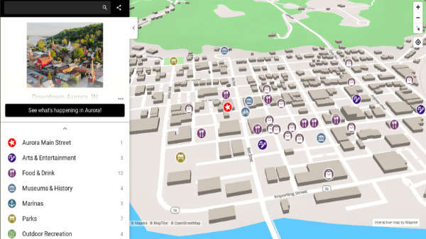
(Southeast Indiana) - Visitors to Southeast Indiana now have a new way to find their way around using MapMe, an interactive map app sponsored by the Dearborn County Convention, Visitor & Tourism Bureau.
Featuring a user-friendly format that’s easy to navigate, the maps include detailed information on the area’s attractions, restaurants, museums, marinas, green spaces, parking, public restrooms and more.
Located along the Ohio River Scenic Byway and home to attractions such as Hollywood Casino, the Lawrenceburg Event Center, and Perfect North Slopes, Southeast Indiana is a growing tourism destination bringing in hundreds of thousands of visitors each year. The region also includes several walkable Main Street communities offering destination dining, shopping, events and historic tours.
The Dearborn County MapMe interactive map allows visitors to click on and further explore the entire Dearborn County region. Additional maps are available for the communities of Lawrenceburg, Aurora and Dillsboro (link to maps).
The maps are accessible by clicking on the wayfinding icon located at the top of Enjoy Southeast Indiana’s official tourism website, www.visitsoutheastindiana.com.
Visitors will also find QR codes linking directly to the maps on the tourism bureau’s printed materials, as well as on signage outside the Dearborn County Visitors Center, 320 Walnut Street, Lawrenceburg, and on window decals located throughout the area.
 Birthday Cards Requested for Local World War II Veteran
 Boone Co. Sheriff's Office Seeking Info After Road Rage Incident
 East Central FFA Compete at District 12 Leadership Contest
 Lane, Ramp Closure on I-275 Eastbound in Kenton County on Friday
 Former Franklin County Judge Banned from Judicial Service