Hail, winds, and the possibility of a tornado loom Tuesday.
Update published at 1:55 p.m.:
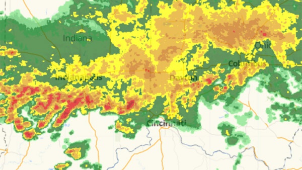
A Tornado Watch has been issued for much of the tri-state.
The National Weather Service says the Tornado Watch will be in effect until 8:00 p.m. Tuesday night for counties in southeast Indiana, northern Kentucky and southwest Ohio.
Meteorologists expect showers to move into the area this afternoon before thunderstorms develop. Some storms could be severe with potentially damaging winds, large hail, heavy rainfall, and even tornadoes.
The National Weather Service estimates the most likely timing for severe weather will be between 5:00 p.m. and 2:00 a.m.
Update published at 8:32 a.m.:
The National Weather Service has implemented a Flash Flood Warning and Flood Warning for parts of the tri-state.
Up to two inches of rain has already fallen in some areas, according to the weather service. The heaviest rainfall was reported along the I-74 corridor, locally affecting Franklin County, as well as northern Ripley and Dearborn counties.
Meteorologists warn that another inch of rain may fall through the rest of the day.
The Whitewater River is expected to go about 5 1/2 feet over flood stage in Fayette County this afternoon.
The Flash Flood Warning will expire at 10:30 a.m. Tuesday. The Flood Warning for the Whitewater River may continue until Wednesday morning.
TRAFFIC: Couple roads closed in Franklin County due to flooding. Stipps Hill Road and Salt Creek bridge. Pipe Creek Road between Snail Creek Road and Hundley Road.
— Eagle Country 99.3 (@eagle993) April 3, 2018
Original story published at 6:27 a.m.:
(Lawrenceburg, Ind.) - Strong spring thunderstorms are expected to sweep across the tri-state Tuesday.
The initial round of storms blew through the area early Tuesday morning. Radar indicated another line of strong winds and heavy rain moving through around 6:00 a.m.
The National Weather Service says yet another series of storms is expected late this afternoon as a cold front crosses east. Those storms may pack hail, damaging winds, and a slight risk of a tornado. Wind gusts may reach up to 45 MPH.
Meteorologists say another one to two inches of rainfall on already saturated soil will bring possible flash flooding. A Flash Flood Watch is in effect for the entire Eagle Country 99.3 listening area.
Listen to Eagle Country 99.3 throughout the day for the latest weather forecasts. View interactive radar on our weather page.
We're expecting busy weather on Tuesday, with storms in the early morning, and more storms by afternoon/evening. Severe weather will be possible! pic.twitter.com/QzLXoO6kmO
— NWS Wilmington OH (@NWSILN) April 2, 2018
 Bridge Painting Project Planned on U.S. 50 in Aurora
 Lawrenceburg Students Create Mural for Lawrenceburg Civic Park
 Dearborn County Man Sentenced 35 Years for Shaking 20-Month-Old
 Osgood Gas Utility to Conduct Routine Gas Leak Survey
 Alert Issued Regarding Emergence of Cychlorphine
 Harrison HS Interact Club to Build U.S. Military Wall of Honor