This is the first in a series this year. As we celebrate the country's 250 Birthday, we will also feature the history of towns in Eagle Country.

Foggy morning view of the Ohio River in Lawrenceburg
(Lawrenceburg, Ind.) - When heavy fog settles at dawn along Lawrenceburg’s stretch of the Ohio River, it can feel as if the past is close enough to touch. In the early hours, the air carries the smell of wet stone and damp timber and beyond the mist comes the steady thump of modern barge traffic moving through the water past the city. But older sounds linger too, if you listen closely—the soft slap of water against driftwood, rope creaking on a dock post, the dull clink of chain, wooden wheels groaning as men strain to move crates, pens, and barrels onto flatboats. Two centuries ago, those sounds meant survival, when a single loose knot could cost a cargo, a livelihood, or a life. They also meant something more: that a new community was putting down roots on the river’s edge, growing with the new country around it.
A historical marker in Lawrenceburg commemorates the city’s founder, Samuel C. Vance. The marker stands in front of the Vance-Tousey House, now home to the Dearborn County Historical Society, at 508 West High Street. According to the marker inscription, Vance founded Lawrenceburg in 1802 but make no mistake, the town was founded because of the river. Before Lawrenceburg came to be, the Ohio River was already the region’s main “highway” for travel, trade, mail, and news.
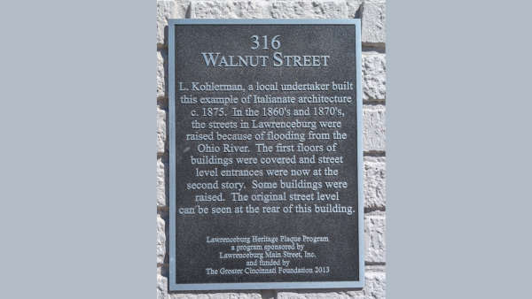
Historical plaque on 316 Walnut St about raising the street due to floods
Early pioneers in Lawrenceburg, like other river towns, used flatboats to move people and supplies all the way to New Orleans. The big, boxy rectangles were typically 20x100 feet in size and would ride about 3-4 feet in the water after being loaded. This feature was very important because before the dams were constructed along our stretch of the Ohio, river level during dry periods could sink to just a few feet deep. After loading the boats they’d drift down the river with barrels and bundles lashed tight, watching for shifting stacks while the pilot used a giant oar to avoid hazards and keep the boat in the main channel and prevent it from turning sideways. A skilled pilot read the river like a map — watching ripples, logs, and color changes in the water. Once at their destination, they would sell their goods, dismantle the boat, sell the wood and walk almost 800 miles home. If they were lucky or rich, they might get a horse to ride. That backbreaking system wouldn’t last forever.
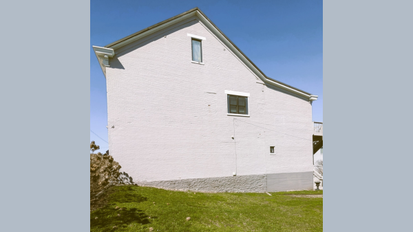
Sideview of 316 Walnut Street showing where the original ground level had been in 1870 before the street was raised.
(Lawrenceburg, Ind.) - For the Hoosier pioneers living in their log cabins on the Ohio River frontier, life changed in 1816, when Captain Henry M. Shreve piloted a powerful, shallow steamboat down the Ohio by placing the engines on the deck. This permitted it to clear the bottom of the river while towing old flatboats loaded with cargo. A steamboat trip from Lawrenceburg to New Orleans and back took about 20 days compared to one-way trips downriver by flatboat that took 4-6 weeks. The really good news was that the deck hands now rode back upstream on the steamboat instead of walking.
Growth from a frontier settlement to a bustling river town moved quickly. Lawrenceburg’s location near the meeting of the Ohio River and the Whitewater River made it a natural stop-and-go point for moving between the river and the interior of the countryside. In those early years, the area’s county lines shifted quickly. Dearborn County was organized in 1803, carved from a larger earlier district that was Hamilton County, Ohio. Between 1812 - 1820 Lawrenceburg became a river-and-market town for surrounding settlers, with more frequent boat traffic, services, and businesses.
The river that sustained Lawrenceburg also repeatedly threatened it. The low-lying area was devastated by multiple floods throughout the 1800s. To reduce the damage caused by flooding, a historical plaque in Lawrenceburg states that in the 1860’s and 1870’s, Walnut Street and other surrounding streets were raised a significant amount. The first floors of buildings were covered by the new higher streets, and street-level entrances were now at the second story. In some of the existing buildings from that era, a visitor can go in the basement and see the original outer doors and windows.
The Ohio River also experienced record dry spells in the 1800’s, which directly affected river travel, day to day life, and further settlement. These water-related events in the 19th century created major challenges for the great-grandparents of current Dearborn County residents.
And still—true to its pioneer spirit—Lawrenceburg reinvented itself again and again: first as a hub of river commerce, then through manufacturing and retail, and later through tourism. In 1997, the casino era came in on the water when the original Argosy opened as a riverboat casino. Lawrenceburg had moved from flatboats hauling freight between foggy shorelines to a flashy riverboat carrying games, restaurants, and entertainment — same river, different century. And the water, like the years, just keeps rolling along!
 Women's Giving Circle Grant Applications Open
 Lawrenceburg Spring Clean-Up Underway
 Dearborn Co. Anti-Litter Initiative Announces First Clean-Up of 2026
 IDHS Focuses on Raising Awareness During Severe Weather Preparedness Week
 Franklin Co. Residents Encouraged to Report Flooding Damage
 Lawrenceburg High School Announces New Tradition for Graduates